Detection of Fires and Burned Areas
Mauro Arcorace – Progressive Systems, Italy
Roberto Cuccu – Progressive Systems, Italy
Carla Orrù – Progressive Systems, Italy
José Manuel Delgado Blasco – Progressive Systems, Italy
Giancarlo Rivolta – Progressive Systems, Italy

During the dry season in Africa a big amount of uncontrolled fires occurs, putting at risk human lifes, properties, crops and environment.
Since 2008 ESA/ESRIN has been supporting the Centre de Suivi Ecologique (CSE) in Dakar, Senegal by operating a dedicated fire detection service (MDIFRM - Multisource Data Integration for Fire Risk Management), that provides in near real time information about fire detections over Senegal and allows the CSE to alert citizens and monitor the identified fires in sensitive locations.
The objective of the Detection Of Fires And Burned Areas activity is to enhance the current algorithm in terms of performance of the anomaly detection, scalability (at least to cover Western Africa) and characterizing the burned areas by PROBA-V data integration.
This activity aimed at continuing to provide support to the CSE, which is interested in receiving near real time fire detections over the ECOWAS countries plus Chad and Mauritania, as well as in collecting post event detections of burned areas, also considering its participation to the the Monitoring of the Environment for Security in Africa (MESA) initiative.
A field validation campaign has been performed in Senegal during the Detection Of Fires And Burned Areas activity where CSE verified in the field the truthfulness of the fires and burned areas detected by our algorithm providing also pictures and additional useful information.
Installing the implemented software on the PROBA-V MEP VM brings more flexibility, a better performance and direct access to PROBA-V and Copernicus Global Land data. The MEP definitely contributes to aggregate a community and to create synergies between different activities, researchers and companies.
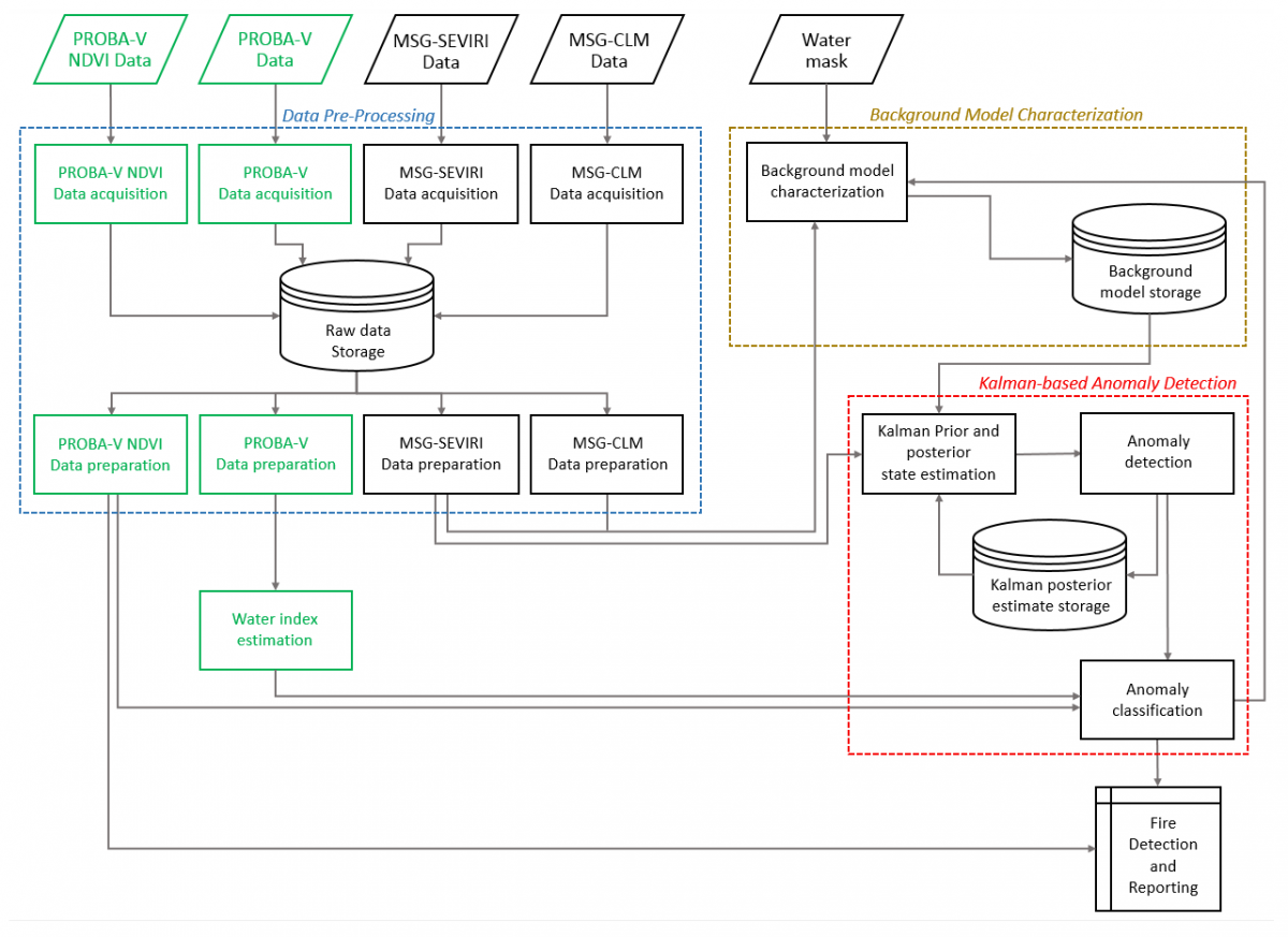
Figure 1: Schema of the implmented algorithm
Detection Of Fires And Burned Areas on the PROBA-V MEP Virtual Machine
The Detection Of Fires And Burned Areas activity has been suppported and continues to be supported by the virtualized environment offered by the PROBA-V MEP: the PROBA-V Toolbox VM.
The software implemented during the activity has been installed on this environment, which is a technology solution offering:
- Flexibility: it provides hardware and software resources that can be customised dynamically
- Performance: it allows the the processing of wide areas in short time, a key point of a near real time service
- Data collocation: it provides direct access to the updated Proba-V and Copernicus vegetation data
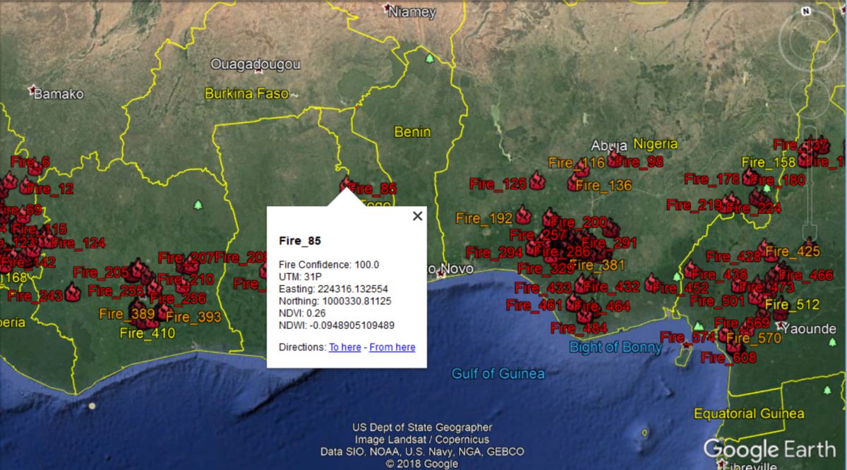
Figure 2: Example of information provided by the Fire and Burned Area Service
Another useful tool that has been exploited during the activity has been the Jupyter Notebook, which provided a faster and user fiendly access to the scripts and software outputs.
Improved effectiveness on the PROBA-V MEP
Working on the PROBA-V MEP has been a totally good experience. The provided virtual environment allows to perform the activity efficiently especially thanks to the provided resources, fast data access and possibility to cooperate, share and work together as a team on the same system.
The technical support provided by the MEP team has been always helpful and responsive, by providing quick answers and effective solutions when required.
Future development
Activities on the PROBA-V MEP will be continued to keep improving the developed algorithm. Moreover a systematic processing might be activated for delivering the fire detection to CSE on a regular basis. The service could also be extended to cover additional areas of interest and to support the provisioning of the detections to new stakeholders.
In iteration 3 a further enhancement on the PROBA-V MEP was implemented to anticipate on the support of MEP web interfaces (WMS, WFS) of browsing and visualization of the results of the fire detections and burnt area information generated by the service. A WFS service gives the end users a fast and easy access to the processing outputs.
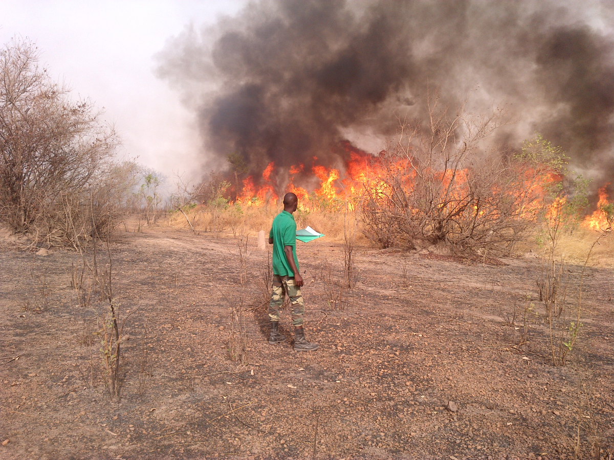
Figure 3: Picture taken during field validation perfomed by CSE teams
References
- M. Diagne, M. Drame, C. Ferrao, P. G. Marchetti, S. Pinto and G. Rivolta, "Multisource Data Integration for Fire Risk Management: The Local Test of a Global Approach," in IEEE Geoscience and Remote Sensing Letters, vol. 7, no. 1, pp. 93-97, Jan. 2010.
- CSE website: https://www.cse.sn/index.php/it/